Week One (VIC ALBUM LINK)
2001

Healesville to Arthur's Track
Friday 23rd March : Healesville to Archeron River
54.2km, 4h 50min.
I learned how to push my bike / The Induction
I slept in this morning until seven forty am;
then checked that my gear was all right.
Stuffed down a banana, a scone and some juice;
Then soaked in a hot shower - one final delight.
The previous evening I had dined with Linda;
who's a trail ‘rep’ right here in Healesville.
She was helpful, kind, positive and said -
“Eat this trout for the trail ain’t no ‘mealsville’”
Now that example of rhyme really isn’t so flash;
But it’s better than my spelling of town names.
As Linda pointed out all over my site;
It’s H-e-a-l-E-s-v-i-l-l-e... I felt I had no-brains
Back to the packing and sorting and stuffing;
A monotonous ritual set to drive me insane.
Strapping and knotting and trying to balance;
I foresee that this part will be quite a drain.
But, ahead lies an experience of sights, challenges and folk;
Which I won’t find in any book or theatre seat.
So I’ll load up my bike, hop on, give HealEsville a wave;
And take the first pedal stroke - for there’s now no retreat.

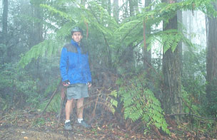
Check out the size of this 'small' fern through the mist on Mt St Leonard.
This was a few kms before I got a little misled.
I pushed my bike up a very steep hill.
I sweated and shivered and I rarely stood still.
I took a very wrong track to a very solid gate.
Which led to a walkers’ track - Oh what a mistake!
I dismounted involuntarily 4 times down a slope,
After pushing and heaving my bike up it- what a joke.
Bitumen! Hurrah! (and downhill as well!)
I cruised into Narbethong feeling just swell.
I stuffed myself silly on salt and lard.
Then cruised into ‘town’ to post a postcard.
I thought I could get just a few more k’s in.
I did - and on the way missed a turn again.
I set up my camp just past the river Archeron.
That was it - my first day done.
Saturday 24th March : Archeron River to Banticks Rd turn
47.9km, 4h 30min.
Some things need to go away.
I had planned to get as far as I could on day #2. Keppels Hut was a possibility but by the end of the day It was just out of reach. Here is a rundown on what happened:
Packed up and was on the road by 9:45am This was quite good - 75 min earlier than day#1. As I had suspected yesterday the trail guidebooks are not entirely accurate. This can be very frustrating when you are looking for a turn... and it doesn't show up until 500m-1.2km later. Went into Marysville to do a phone check in with the police and my sister. Mobile didn't work in town so I suspect I won't get messages until Omeo (say like Romeo) or else Canberra. Wondered what all the delinquents were doing hanging about - it’s Saturday.. no school! Got some muesli bars and scoffed a Mars bar.
Did a detour just out of Marysville to see Steavenson Falls. Quite nice - see photo in Trail History (VIC). Toilet doors don't lock there. On the road again to a mammoth uphill. The track at the top was great (rolling little slopes with a variety of scenery). Got to another bitumen road and cruised downhill (all bitumen must be downhill I think). The map I had said I'd be in for some more downhill on a track called Cameron’s Cascade Track. Did 4-5km/hr down the last 1.5km of this track (don't go up this one Martin!). Got tossed smartly off my bike. Panniers and gear stayed on perfectly which added to my astonishment. The length of this downhill made me very aware that there would be a considerable uphill ahead. (This is a very interesting thing - up hills are good because you know a downhill follows, but if it’s too far down then you get disappointed because you know it’s going to be another big uphill. Another thing with down hills : don't fight to get your map to stay in your pocket cruising downhill or try to look back to kick your panniers back into place - the road’s edge is never too far away.)
Got to another set of falls - Keppel Falls. Had a rowdy reception when I arrived at the picnic/walk area from the 4-5 minibus loads of Melbourne uni students who were on a bit of an outing. Talked in the drizzling rain for about half an hour and got a 3:30pm lunch of pita bread with lettuce and peanut butter... and you might not like the sound of that but it was real tasty. Probably the last bread I'll eat in days. Thank fellas! Got lots of questions and discussed the intricacies and merits of such a ride.
Cycled a long up hill (it had to come) in the drizzle a bit depressed with the onset of rain. Rode until 5pm when I found a camping spot in a side road at 1000m elevation. Set up camp cold and wet. Got dry and organised and was just going to go to sleep but thought that would not be good. Cooked a meal of tuna spag bolognese See photo in Menu Ideas. Used drained spag hot water to make hot cocoa and yes, it was bloody good. Leech fell from the sky onto my arm after dinner. Got him before he got me. Cleaned up and started typing this. Leech fell onto keyboard from tent ceiling (?) and I removed him with uncoordinated haste. Go away leeches. I'm going to go to bed.
For the second day in a row the sun has come out after I have gotten into my tent for the night.
Sunday 25th March : Banticks Rd turn to Arthurs Creek Tk
44km, 4h 42min, max 45km/hr.
Huts are a good thing.
Post note : Leech got me between the fingers. Because he didn't like the friction (or smell?) of me running my fingers through my hair he fell on the keyboard. I discovered this moments before I went to sleep.
Sunshine! I was eager to get on my way with the depressiveness of rain gone. The clouds were still there, but that's always a worry reserved for later.
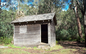
After a moderate stretch of pushing and slow cycling uphill I reached Keppel’s Hut (See Trail History (VIC)).
It was a mansion. Well nearly. As you can see it's well built, has a fireplace and inside are bunk beds and a table and chairs. A little spring is a few steps away and it's well sheltered from the wind. Much better compared to a tent. If only I didn't talk to those uni students for so long yesterday!

I had heard some grinding/rubbing sounds as I ascended to the hut and so checked out what it was - a bent rack from the right pannier scraping the tyre when under pressure. Had to unload all gear. This gave me a chance to dry some damp stuff in the sun which was good. Removed the rack and slowly bent it back into shape (waiting for a dreaded crack). Had a bite to eat and then took some photos. Left my first topo map there as it was off limits 4 km further on and just extra weight for me. Hopefully someone will find a use / interest for it. Probably good to start that fireplace with.
A shorter but steeper climb/push got me away from the hut, then there was a long downhill through some open woodland into a logging area. A no entry sign suggested that I turn around and go back. Like they're going to be working on a Sunday... nice one. Besides my momentum coming down the road (logging roads are usually nice and smooth and of an easy gradient) was too great and any falling trees would have missed me. At the other end of this 'zone' was a sort of a gate like 2 capital A's with the points together. Thought I'd have to struggle around them... or even worse remove gear and then re pack it... but was able to slip through with about an inch to spare all round once I ducked my head.

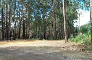
Photo : See the BNT Marker on the tree in the foreground? It's at the base of the dark patch... you've really got to look ward when riding as you're usually more worried about the road surface! This is the logging road that leads towards Mt Bullfight.
Nice cruisy roads for a while both up and down. The road up past Mt Bullfight (1480m) was after a bridge over the Royston River. Pushed my bike 3km up it, but by now I'd had a lot of practise. A varied descent and then onto Cons Gap Rd which was enjoyable pedaling. Took a photo of the range looking towards Mt Terrible but it didn't come out right, so you won't see it here! Just after the photo was taken I rode down through a logged area and came to a Y junction. No trees that had BNT markers and the tracks/option didn't appear on either of the maps I had. Both looked equally worn. Ummed and ahhed, looked at maps, took bearings, considered instinct. Guessed that instinct would be right along with the hint from the topo map that the track should follow the contour closely in a roughly north direction. Well done Michael, fellow travelers : always take a topo map and consider your instinct.
Hugh's Track is total crap. That's the perfect way to describe it. It's a bad feeling when you have to end the day somewhat distressed because of the last bit of track you travel along. This track had it all : steep and rocky, hard to distinguish from the bush at times, littered with sticks and leaves that were hiding ruts, overhanging and fallen branches, vines, little ledges, rutted axle deep silty bogs on some corners (sometimes all of this at once) and it was longer than the guidebook suggested. At this stage I had nowhere in mind in particular to camp, but it wasn't going to be anywhere on this horror of a pathway.
The suggested next camp at Taponga River was a little out of reach so I was happy to stop where 5:30pm found me. This was about a kilometre after Hugh's. I hadn't camped at a suggested campsite yet.
Notes:
Week Structure - My week starts on a Monday. Technically it's not normal practise - it's a 'count your weekly running km' habit that has spilled over into the rest of my organisation.
Martin - If you go up Hugh's Track, good on you. I'd stick to Snobs Creek Road on a MTB. Wise to the word 'track' and the vast difference between it and 'road'.
Shauno - It's been non stop hits from the 80's in my head. None are songs I've heard recently and strangely they don't last very long. Was able to tune into JJJ on night #2 which was cool - the only station besides some Greek and classical jazz channel from Melbourne.
Trek Essentials - Gaffa tape (mine's nearly used already from patching all types of bags and water containers), a tarp (mine's twice as big as it needs to be but no doubt I'll use the whole size at some stage ...eg. if I need to cover the whole bike - wraps up all gear nicely so you don't have stuff hanging around in the tent or vestibule; light, easy to pack and secure, and is generally handy). [Also known as Duct Tape.]
Looking back - Hugh's Track was a great experience and showed the diversity of the trail. I'd do it again... going down of course! It's been a wet and oft miserable start to a very long journey.
Week One
March 23, 2001
“An adventure is only an inconvenience rightly considered. An inconvenience is only an adventure wrongly considered.”
All Things Considered -
G.K.Chesterton, 1908
